Log in
All resources
Create a design
11,660 Free Images of Old Map
maps by willem and johannes blaeu
baroque
bibliothèque nationale de france
old maps of lüneburg
david rumsey historical map collection
atlas novus (blaeu)
images of places from encyclopædia britannica
emery walker
maps from encyclopædia britannica
lucas janszoon waghenaer
turgot map of paris – derivative files
château de la tournelle (paris)
maps from the earth and its inhabitants, vol. xi
africa in the 1890s
gemeente atlas van nederland - south holland
old maps of eiland van dordrecht
turgot map of paris, kyoto university library – derivative files
palais du louvre on old maps
old maps of the arctic
maps by emanuel bowen
eran laor cartographic collection
french-language maps
maps by willem and johannes blaeu
old maps of alexandria
carte de la mer mediterranée (1764) by roux
eran laor cartographic collection
maps by willem and johannes blaeu
old maps of hesse
topographia braunschweig lüneburg (merian)
baroque
maps by willem and johannes blaeu
old maps of zutphen
david rumsey historical map collection
17th-century maps of iceland
1820s maps of indonesia
old maps of east timor
18th-century french nautical charts
historical images of souda bay
algeria in the 1880s
old maps of oran
1570s maps of russia
frans hogenberg
maps of luxembourg city walls
old maps of luxembourg city
maps in the library of congress
old maps of anniston, alabama
maps of paris from bibliothèque nationale de france
sheet 10 of the turgot map of paris
media from the national library of finland
classicism
maps by willem and johannes blaeu
1640s maps of ukraine
19th-century maps of dresden
johanniskirche (dresden)
maps from the earth and its inhabitants, vol. xvi
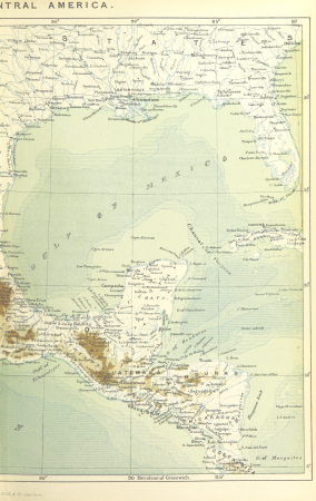
1870s maps of mexico
old maps of algiers
maps from gallica
africa and its inhabitants, vol. ii
charles eugène perron
collections of stadsarchief delft
old maps of delft
maps of paris by bernard-jean-hyacinthe jaillot
maps of paris from paris musées
gemeente atlas van nederland - north holland
maps of schermer
portolan charts by willem and johannes blaeu
old maps of holland
guide joanne espagne et portugal-1915
1915 maps
topographia alsatiae (merian)
baroque
maps in the library of congress
animals on maps
maps by willem and johannes blaeu
siege of groenlo 1627
tourism advertising posters of germany
1935 maps of germany
old maps of north brabant
1645 maps of belgium
building
maps
pages with maps
cc-pd-mark
maps of ancient israel by philippe de la rué
map of modern syria by philippe de la rué
hamburg in the 16th century
maps of hamburg-altstadt
images of places from encyclopædia britannica
old maps of edinburgh
rus' (eastern europe)
1747 maps of russia
maps by willem and johannes blaeu
old maps of groningen (city)
maps by christian sgrothen
manuscript maps
self-published work
gold
old maps of haarlem
museum haarlem
hendrik van langren map of south asia
renaissance
maps by willem and johannes blaeu
old maps of the republic of genoa
1580s maps of the netherlands
1580s maps of belgium
images of places from encyclopædia britannica
old maps of edinburgh
maps of île d'oléron
atlas maior
images of places from encyclopædia britannica
old maps of manchester and salford
roman catholic archdiocese of salzburg
old maps of salzburg (state)
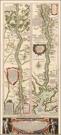
engravings of topographia braunschweig lüneburg
baroque
topographischer atlas der schweiz
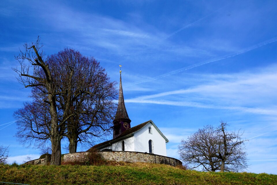
old maps of zollikerberg
17th-century maps of north carolina
old maps of virginia
maps by willem and johannes blaeu
old maps of schoonhoven
maps by willem and johannes blaeu
old maps of diksmuide
maps of paris from the david rumsey historical map collection
romanticism
old maps of skagerrak
maps of oslofjorden
engravings of topographia braunschweig lüneburg
baroque
nicolaas samuel crucquius
old maps of delfland
maps by willem and johannes blaeu
old maps of swabia
old maps of milan
domenico aspari
st. helena - a physical, historical, and topographical description of the island (1875) by melliss
maps from the mechanical curator collection
maps of ghent by hendrik hondius
old maps of spanjaardenkasteel
1610s maps of the netherlands
old maps of friesland
maps by matthäus seutter
kačina
old maps of the dutch east india company - malaysia
maps of the dutch east india company - indonesia
maps of midden-delfland
old maps of delfland
gemeente atlas van nederland - south holland
1860s maps of south holland
history of sherbrooke (quebec)
1881 in quebec
maps of cambrai city walls
old maps of cambrai
maps of antwerp city walls
old maps of antwerp
maps from the earth and its inhabitants, vol. x
1890s maps of egypt
maps of ceylon by petrus plancius
ketheeswaram temple
maps by willem and johannes blaeu
old maps of emden
maps by willem and johannes blaeu
1649 maps
maps from the earth and its inhabitants, vol. xii
1892 in africa
maps by willem and johannes blaeu
old maps of wageningen
maps of lidingö
1774 in sweden
old maps of middelburg, zeeland
atlas van loon
media from regionaal archief alkmaar
old maps of koedijk
de nieuwe en onbekende weereld
1671 illustrations
petit atlas pittoresque des 48 quartiers de la ville de paris, david rumsey historical map collection
maps of paris from the david rumsey historical map collection
maps by pieter van der keere
southwark, london
maps by willem and johannes blaeu
17th-century maps of india
old county maps of essex
christopher saxton
maps of castile by mercator-hondius
details of old maps
old maps of rostock
caspar merian
old maps of the province of a coruña
lucas janszoon waghenaer
maps of paris from bibliothèque nationale de france
maps of paris by john rocque
maps from the mechanical curator collection available to georeference
maps from the mechanical curator collection
grosser deutscher atlas
old maps of portugal
old maps of coevorden
atlas van loon
maps from the mechanical curator collection available to georeference
maps from the mechanical curator collection
turgot map of paris, musée carnavalet
maps of paris from paris musées
maps from university of amsterdam special collections
atlas der neederlanden
old maps of frankfurt (oder)
old maps of brandenburg
propaganda map
1529 maps
the turkish empire in europe, asia and africa (1752)
history of bursa
7501 - 7600 of 11,660
Next page
/ 117


![[Facsimile of part of Turgot's plan (Laune district) used as advertising for the Becker fils house]](https://cdn.creazilla.com/illustrations/10000809874/facsimile-of-part-of-turgot-s-plan-laune-district-used-as-advertising-for-the-becker-fils-house-md.jpg)